
Friday, February 26, 2010
Lab Module 5 - Georeferencing
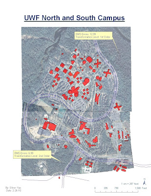
Here is my Lab 5 - Georeferencing map of UWF. This lab was a lot of fun. I had issues at first with the RMS errors being really high. Once I started zooming in and adding points my RMS values dropped significantly. I also would delete any high values and use new points to being the RMS down. I am suprised that my RMS was so low for south campus. I also only had to use 10 points.
Sunday, February 21, 2010
Lab Module 5 - St. Lucie County
Here is my map for St. Lucie County, Florida. This was a fun lab trying to find all the data sources. I did have problems with the DRG, DEM, DOQQ at first but found some help from a classmate.

Wednesday, February 10, 2010
Haiti Earthquake Response Map
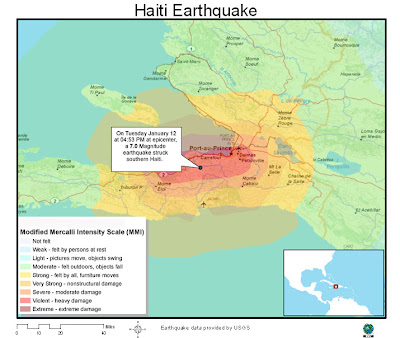
Below is a map I found while browsing the web for Haiti GIS maps. The map is from Esri and it displays the Modified Mercalli Intensity measurements for the areas surrounding the affected region. This map is helpful in showing where the most intesity was felt and the relation to major cities in Haiti.

Tuesday, February 9, 2010

Tuesday, February 2, 2010
Week 3 Lab
Map 1 - Mexico Populations

Map 2 - Mexico Rivers, Railroads, Federal Roads, and Urban Areas

Map 3 - Mexico Elevations

Subscribe to:
Posts (Atom)